


THP Engineering
Surveyors and Associates

Services

Topographic Diagrams
Recording and Preparation of a Topographic Diagram of your property for any type of work (notarial deed, settlement, identity, building permit).
Integrated into the state coordinate system EGSA '87, in accordance with current legislation and applicable technical specifications.

Geometric Changes Chart - Cadastre
Preparation of a Geometric Changes Diagram (GCD) for the correction of plot boundaries in the Greek Cadastre, as well as for acts of merger, division, establishment of vertical properties and easement of passage.
Posting of the diagram in the Land Registry and issuance of a Land Registry Certificate .
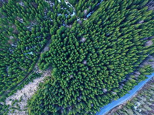
Photo interpretations - Forestry
Photo interpretation of historical and contemporary aerial photographs and preparation of a Technical Report to document the historical form and use of an area.
Support for forest map assumptions, age of buildings, definition of shoreline, location of watercourses and other natural or artificial changes.

Surveys - Engravings
Site Support
Topographic surveys and markings through appropriate control networks, to ensure the accuracy and proper implementation of your construction project.
Topographic support is provided throughout the work, with the aim of minimizing errors and deviations and, consequently, reducing the cost and execution time of the project.

Property Identification & Demarcation
Identification and demarcation of land and parcel boundaries through a combination of topographic measurements, contracts, old topographic diagrams and available cadastral data.
Accurate mapping and marking of boundaries on the ground, with the aim of documenting the location and extent of the property.

Mapping & Demarcation of Streams
Topographic survey, elevation control and production of a 3D terrain model, to determine the flood lines and the demarcation (temporary or final) of the watercourse near your property. Submission of the required file to the competent service to ensure buildability.

Drone Services
Aerial photography and mapping of properties using Drone (Unmanned Aerial Vehicle), for the accurate documentation of the existing condition and characteristics of an area. Production of orthophotomosaics and 3D models.
Identification of boundaries and mapping of inaccessible areas. Support for topographic, property and urban planning matters.

GIS Services - Mapping
Utilization of Geographic Information Systems (GIS) technologies for the collection, processing, analysis and visualization of spatial data.
Creation of digital maps of urban or natural environments and databases for the integrated management and utilization of real estate, as well as the support of technical, urban planning and investment decisions.

Vehicle Entry/Exit Studies -
Temporary traffic arrangements
Preparation of vehicle entry-exit studies for the safe and functionally correct connection of properties with the existing road network, as well as studies of temporary traffic regulations for the safe conduct of work on or near the roadway .


Projects


Who we are
The THP Engineering team relies on the expertise of two specialized and experienced Surveyor Engineers and a wide network of partners, offering comprehensive technical solutions for issues related to property ownership and development.
Christos Theodoridis is a Survey Engineer from the National Technical University of Athens, a member of the Greek Professional Association of Surveyors, a holder of a study degree in public works, with a postgraduate specialization in Urban and Rural Planning, traffic studies and geoinformatics applications (GIS).
Dimitris Papageorgiou is a Survey Engineer from P.A.D.A., a member of the Greek Professional Association of Surveyors, a certified UAV (Drone) pilot, specializing in topographic applications for road construction, watercourses and implementation operations.
Our experience in the design, supervision and construction of public and private projects throughout Greece, combined with our modern, high-precision proprietary equipment and our specialized partners - architects, civil engineers, hydraulic engineers and lawyers - allows us to comprehensively and responsibly deal with every technical and property matter.
We believe that clear communication with the client is as important as technical excellence. For this reason, we keep you informed at every stage and ensure that the final result fully meets your expectations.
Service
throughout Greece


Communication
